38°N (DMZ), 2025, 40 x 60 inches, Acrylic on canvas
38°N (Freedom Village), 2025, 40 x 60 inches, Acrylic on canvas
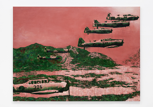
38°N (T-6), 2025, 50 x 60 inches, Acrylic on canvas
Photo: LF Documentation
This series depict the elusive landscapes of the Korean Demilitarized Zone (DMZ) and Freedom Village. Based on a black-and-white archival photograph from the National Archives of Korea, the paintings take its title, 37° 56’ 28.03” N 126° 40’ 44.92” E, from a coordinate within the DMZ (vast regions also including Freedom Village)—an area paradoxically untrackable by GPS. This absence from digital mapping evokes a strange sense of presence through erasure, where places are real yet rendered inaccessible, much like the DMZ itself. By erasing DMZ from GPS systems, the state transforms a real, inhabited space into a strategic abstraction—just as it reduces individual bodies into depersonalized instruments of warfare, stripping them of subjectivity and reframing them as extensions of state power. To re-embody this paradox, I projected the sourced archival photograph onto canvas in complete darkness—not to replicate, but to invite abstraction and instability. Painting with only the glow of projection, I worked in a restricted palette of Korean military green (National Color of Defense) and flesh tones. These colors collapse boundaries between uniform and skin, evoking how camouflage overtakes the body. The image, like memory, gradually emerges; layered, uncertain, and shaped by chance. This process echoes darkroom photographic development, where revelation depends on time, touch, and light. The result is a surface that remembers and resists, confronting viewers with the contradictions of visibility, history, and national identity.